Holiday in the CR:CZeCOTTourmapsEast BohemiaUNESCOCzech inspirationGEOFUN
loading...
Tourist navigator
Viki
Official tourist portal of Pardubice region
Czech Republic
Partly cloudy 18°C
the weather

Weather - Pardubice

14.5. (17:11)
today
Partly cloudy
18°C
15.5.
tomorrow
Partly cloudy
19°C/9°C
16.5.
ThursdayOvercast
16°C/10°C
17.5.
FridayOccasional rain
12°C/10°C
Source: Weather Meteocentrum

Inline skating

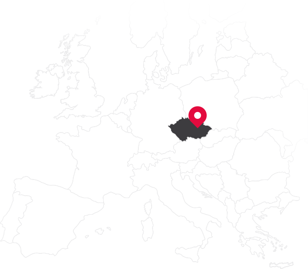
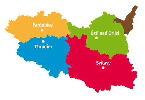
East Bohemia offers unrivalled conditions for inline skating. The Orlicko-Třebovska area has built a 40 km network through the valleys of the Ticha Orlice and Třebovka Rivers, through the cities Choceň, Ústí nad Orlicí, Letohrad and Česká Třebová with access prohibited to motor vehicles and is rightfully referred to as a heaven for cycling and inline skating. There are also a number of trails in the surroundings of Pardubice. read more

Search buildings

Map

Search results Export data for GPS device in GPX format

ATC Šlechtův Palouk.
Pastviny 451, Žamberk
724147317 465637294
B. Modrý Sports Hall.
Za Střelnicí 551, Lanškroun-Ostrovské Předměstí
465320418 604872778
Skatepark Pardubice.
Kpt. Bartoše 2788, Pardubice
737013976
Sporthotel Tichá Orlice.
V Lukách 1362, Ústí nad Orlicí
465322764 733373377
(Sport centrum Doleček).
Aloise Hanuše 122, Jablonné nad Orlicí
465642236 733642116 465642708 603275691 604284253
Topsports Centre Rental Shop.
Stříbrný rybník 130, Hradec Králové
607877724
On the Courts Tennis Centre.
U Stadionu 528/15, Svitavy
603793463
Pohledy 153
602403629
(In-line školička).
Karpatská 231, Ústí nad Orlicí
602245393
Skatepark Pardubice.
Kpt. Bartoše 2788, Pardubice
737013976
(In-line školička).
Jiřího Potůčka, Pardubice
602245393 723391261
Topsports Centre Rental Shop.
Stříbrný rybník 130, Hradec Králové
607877724
Pardubice - Staré Jesenčany (1.6 km)

The trail begins at the garage by the airport in Pardubice. You can meet a car during the first approximately 2oo metres, however, further on vehicles no longer have access thanks to a concrete barrier...

planner
 Export data for GPS device in GPX format
Svitavy - Vendolí.
Svitavy - Vendolí (3.2 km)

The unlit trail is approx. 3 metres wide with rest areas and meanders through the Patriots Park and through the fields to Vendolí. At the end of the gardens you need to be careful when descending in the...

planner
 Export data for GPS device in GPX format
 Export data for GPS device in GPX format
Svitavy - Lačnov.
Svitavy - Lačnov (2.6 km)

3.5 metre wide back road near Svitavský Lačnov, which only farm vehicles and other vehicles with a special permit are allowed to access.

planner
 Export data for GPS device in GPX format
Svitavy stadium.
Svitavy stadium (1.1 km)

The complex offers a number of freely accessible family and sports activities: a 1.2 km long circuit for inline skating, 2x pentanque fields, a large streetball court, 2 children's playgrounds for small...

planner
 Export data for GPS device in GPX format
Týniště nad Orlicí - Petrovice.
Týniště nad Orlicí - Petrovice (1.5 km)

Cycling trail along the frequented road no. 11. The trail is sufficiently wide with a quality and flat surface.

planner
 Export data for GPS device in GPX format
Ústí nad Orlicí - Letohrad.
Ústí nad Orlicí - Letohrad (12.8 km)

The trail called "Ticha Orlice through the valley" boasts a new wide asphalt surface, small markings and a number of resting areas. When riding, be careful in the village Oldřichovice where you need to...

planner
 Export data for GPS device in GPX format
Holice - Ostřetín.
Holice - Ostřetín (3.1 km)

The trail leads from Holic along a former 6 metre wide road for approx. 350 m, where the right half is reserved solely for inline skaters and the left is bidirectional for pedestrians and cyclists. Moreover...

planner
 Export data for GPS device in GPX format
Lanškroun - Albrechtice.
Lanškroun - Albrechtice (1.9 km)

Cycle connection of Lanškroun and Albrechtice built along road 1/43.

planner
 Export data for GPS device in GPX format
Velké Petrovice - Maršov nad Metují (3.1 km)

A trail with a quality surface between fields. The width of the trail is around 3 m.

planner
 Export data for GPS device in GPX format
Opatov.
Opatov (0.7 km)

It is a former road, which was moved by 15 metres to the side and is now a blind road that is no longer in use by motor vehicles.

planner
 Export data for GPS device in GPX format
Stěžery - Stěžírky (0.9 km)

A trail with a quality surface. It leads gently uphill in the direction of Stěžírek. However, be careful of fallen branches or leaves.

planner
 Export data for GPS device in GPX format
Veliny - Borohrádek.
Veliny - Borohrádek (3.4 km)

Asphalt surface without defects or holes. The trail is more challenging due to its vertical rise and for the greater part it leads through a forest.

planner
 Export data for GPS device in GPX format
Lázně Bohdaneč - Živanice (2.3 km)

The trail begins at the end of Bohdanec Spa on the exit in the direction of Přelouč. The beginning of the trail is made from interlocking pavement, which changes into a quality asphalt surface after 200...

planner
 Export data for GPS device in GPX format
Písečnice.
Písečnice (3.3 km)

The trail leads from the crossroad at Hájenka all the way to Nový Hradec and extends the Hradečnice trail. You have to be careful of the sharp 8% descent in front of the crossroad.

planner
 Export data for GPS device in GPX format
Svitavy - Javorník.
Svitavy - Javorník (1.5 km)

The trail is approx. 1.5 km wide with public lighting.

planner
 Export data for GPS device in GPX format
 Export data for GPS device in GPX format
Pardubice - Ráby.
Pardubice - Ráby (5.3 km)

The route of the trail starts at the Cihelna swimming pool and leads along the Labe River through Brozany all the way to Raby. At the beginning of the trail, you need to be wary of vehicles that use this...

planner
 Export data for GPS device in GPX format
Sezemice – Pardubice .
Sezemice – Pardubice (4 km)

In Sezamice, turn left off the main road in front of the bridge over Loučna Stream (in the direction away from Pardubice). There is a small car park and rest area by the trail. Until about halfway through...

planner
 Export data for GPS device in GPX format
Svitavy-Lány -
Svitavy-Lány - "Žabka" (2.8 km)

It is a trail with access permitted only for agricultural machinery, which is rarely found here. The trail is lit and is about four metres wide. Due to the hilly profile is intended only for experienced...

planner
 Export data for GPS device in GPX format
Dříteč (around the golf course) (4 km)

A trail with a quality surface intended for inline skaters only. It leads around a golf course.

planner
 Export data for GPS device in GPX format
Dachova - Potoky (1.3 km)

planner
 Export data for GPS device in GPX format
Trail through the Botanical Gardens.
Trail through the Botanical Gardens (0.4 km)

The site of the former Botanical Garden offers peace, invites you to a stroll and provides a view of part of the fortifications. In 2014, paths for pedestrians and cyclists were created in the area of...

planner
 Export data for GPS device in GPX format
Dašice - Kostěnice (1 km)

Short trail with a quality, flat surface beginning behind the indicator of the village Dašice (in the direction of Hrochův Týnec). The end of the trail is ay the entrance to the village Kostěnice. Car...

planner
 Export data for GPS device in GPX format
Hradečnice.
Hradečnice (2.8 km)

Cycle trail within the Town Forests with slight ascents in the terrain hidden in the forest. The minor disadvantage of the trail is the possibility of branches and acorns on the trail. You can also encounter...

planner
 Export data for GPS device in GPX format
Choceň – Vysoké Mýto.
Choceň – Vysoké Mýto (5.3 km)

The trail is suitable for more experienced riders. The trail is sufficiently wide, straight but it is covered with rougher asphalt and several ascents and descents await us along the way. It is best to...

planner
 Export data for GPS device in GPX format
České Libchavy - Paseky.
České Libchavy - Paseky (0.6 km)

3 metre wide trail with lighting for pedestrians and cyclists.

planner
 Export data for GPS device in GPX format
Kuks - Brod (1.6 km)

planner
 Export data for GPS device in GPX format
Kostelec nad Orlicí - Doudleby nad Orlicí.
Kostelec nad Orlicí - Doudleby nad Orlicí (2.2 km)

Quality, flat surface along the railway tracks and garden colony

planner
 Export data for GPS device in GPX format
Podůlšany - Čeperka (1.9 km)

The trail along the Opatovicky channel leads along the road connecting Podůlšany with Čeperka. Lorry traffic is restricted, but passenger vehicles can commonly be encountered here.

planner
 Export data for GPS device in GPX format
Hostinné (1.3 km)

planner
 Export data for GPS device in GPX format
Pardubice – Černá za Bory (1.9 km)

There is no car park at the beginning of the trail, but there is one near Foxconn. Unfortunately after 600 m the trail is interrupted and it is necessary to continue along 100 m on a busy road. Then we...

planner
 Export data for GPS device in GPX format
Šedivský lom.
Šedivský lom (1.6 km)

The biathlon grounds are accessible to the public outside of training and sports events.

planner
 Export data for GPS device in GPX format
Pardubice (Cihelna) - Rosice (2.7 km)

Sufficiently wide trail with a quality surface which can be enjoyed all the way to the bridge, which joins Polabiny with Zeleny suburbs, from where the trail is bumpy and penetrated by tree roots in some...

planner
 Export data for GPS device in GPX format
Třebechovice pod Orebem - Týniště nad Orlicí (7.2 km)

Forest trail, mainly flat, with a quality surface in the first half, occasionally damaged in the second half, nevertheless, a good surface. You have to watch out for 2 railway crossings, which intersect...

planner
 Export data for GPS device in GPX format
Vysoké Mýto - along Hradec Street.
Vysoké Mýto - along Hradec Street (1 km)

Approx. 3 m wide trail with access to motor vehicles forbidden.

planner
 Export data for GPS device in GPX format
 Export data for GPS device in GPX format
Chrudim – Slatiňany.
Chrudim – Slatiňany (2 km)

The cycling trail begins along the left side behind the bridge over the Chrudimka River. There is a short and steep descent from the main road, along which there is a bench where you can change your shoes/skates...

planner
 Export data for GPS device in GPX format
Chrudim - Medlešice (2.2 km)

It is a former wide dirt road that has been paved into the form of a 3 metre wide high quality cycle trail, which has lighting along its entire length. It has a flat profile with the start slightly inclined...

planner
 Export data for GPS device in GPX format
 Export data for GPS device in GPX format
Dvůr Králové nad Labem - Žireč (3.1 km)

Newly paved trail, suitable for both children and inline skating beginners, who needs to train their technique, as certainly everyone can manage the nearly flat terrain. The trail begins on Žirecká Podstráň...

planner
 Export data for GPS device in GPX format
Praskačka - Lhota pod Libčany (3.2 km)

The trail with a quality surface is rather wide and flat. Vehicle are forbidden to access it. Nevertheless, be careful as the occasional car drives onto the trail in spite of the ban.

planner
 Export data for GPS device in GPX format
Petrovičky - Nová Ves (2.3 km)

A trail with a quality surface leading through a forest. Please be careful of occasional debris (stones, leaves...). The trail is somewhat narrow; however, not used frequently by skaters.

planner
 Export data for GPS device in GPX format
Kerhartice - Choceň.
Kerhartice - Choceň (14.8 km)

The cycling trail has a good quality surface and is 2.5-3 metres wide. It is necessary to ride along the road from the village Perna in the direction of Brandýs nad Orlice. On the left side cross over...

planner
 Export data for GPS device in GPX format
 Export data for GPS device in GPX format
Rosice - Semtín (1.6 km)

The trail leads along the local markings of the cycling trail, marked by green round signs with a cyclist and white indicators. The surface is not so good here. After passing through the forest you need...

planner
 Export data for GPS device in GPX format
Lázně Bohdaneč - Semtín.
Lázně Bohdaneč - Semtín (2.6 km)

The cycling trail leads from Bohdaneč Spa along the road in the direction of Pardubice and is wide enough for comfortable skating. Before arriving at Rybitvi, be careful of the downhill ride.

planner
 Export data for GPS device in GPX format
Žamberk - Líšnice.
Žamberk - Líšnice (1.3 km)

3 metre wide cycling trail with quality, flat surface and two simple resting areas, including new traffic signs.

planner
 Export data for GPS device in GPX format
Ústí nad Orlicí - Česká Třebová.
Ústí nad Orlicí - Česká Třebová (10.4 km)

The cycling trail through the valley of the Třebovka River leads mainly along local roads with various surface qualities. Two sections are suitable for skaters. The first section is 1 km long and begins...

planner
 Export data for GPS device in GPX format
Svitavy - connection from the gardens.
Svitavy - connection from the gardens (0.3 km)

The unlit trail is approx. 3 metres wide with rest areas and meanders through the Patriots Park and through the fields to Vendolí. At the end of the gardens you need to be careful when descending in the...

planner
 Export data for GPS device in GPX format
(1.7 km)

The village of Litic is 9 km south of Dvur Kralove nad Labem. Two formerly farm roads in the village were converted into new tracks suitable for inline skating.Track One runs through the village, around...

planner
 Export data for GPS device in GPX format
(1 km)

The village of Litic is 9 km south of Dvur Kralove nad Labem. Two formerly farm roads in the village were converted into new tracks suitable for inline skating.Track One runs through the village, around...

planner
 Export data for GPS device in GPX format

Tips for trips

From Hradec Králové to Kuks.
From Hradec Králové to Kuks

This trail familiarises visitors with historic treasures of the Hradecko region. The trail runs through the beautiful Elbe River valley, mostly in close...

planner